Editor’s Note: Call to Earth is a CNN editorial series committed to reporting on the environmental challenges facing our planet, together with the solutions. Rolex’s Perpetual Planet Initiative has partnered with CNN to drive awareness and education around key sustainability issues and to inspire positive action.
CNN
—
At the end of July, Colorado became the latest US state to battle the spread of wildfires. Four blazes broke out, and while most are now contained, sustained hot, dry conditions this summer could spark more.
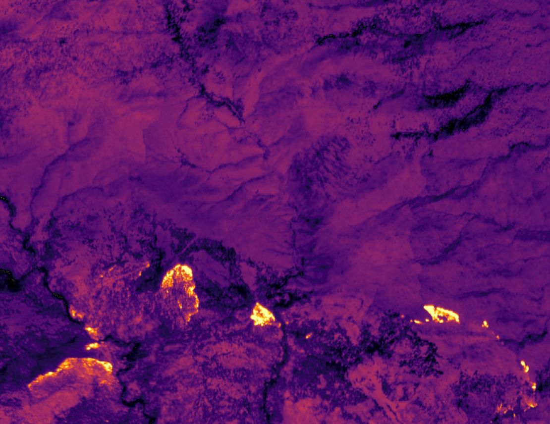
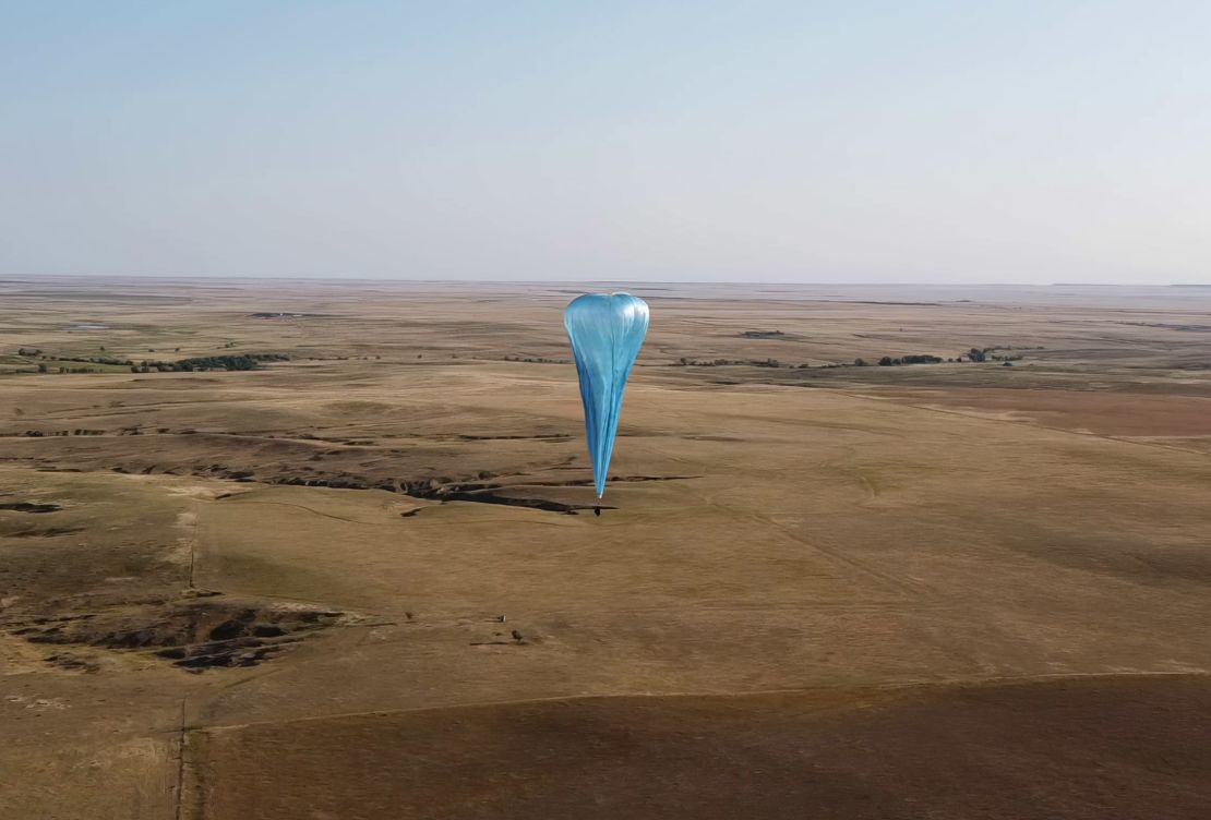
Around the same time, on August 1, a giant balloon was launched from the back of a pickup truck. Floating up to the stratosphere, the region between four and 31 miles above the Earth’s surface, it was able to capture high resolution photos of the Alexander Mountain fire, near Fort Collins, and measure temperature points on the ground.
The launch had been planned for months by the startup Urban Sky, which designs high-altitude balloons. It is the first of a handful of balloons due to be deployed in the next four weeks as part of a commercial trial looking to test the technology as an inexpensive way to detect, track, and ultimately prevent the spread of wildfires.
“The main goal is all about fire intelligence and early detection of wildfires,” Jared Leidich, co-founder and chief technology officer at Urban Sky, tells CNN.
Equipped with various infrared sensors, the balloons map vegetation density and moisture content on the ground, he explains. This data is processed in real time and combined with intelligence about dry lightning strikes and other ignition sources to come up with a “risk score” for certain locations, effectively pinpointing areas where a fire is likely to break out.
Another sensor measures heat on the ground. “Temperature is a really important distinction for early detection,” says Leidich. “Right now, most fires are detected just due to the presence of visible smoke … What you can’t tell from something that’s smoking is whether that is the end of a smoldering fire that is about to go out and probably harmless, versus a very hot building fire that is about to spread.”
All of this data is transmitted to computers on the ground via a satellite link, accessible to anyone with an internet connection. While still in the testing phase, Urban Sky plans to upload the data into a fire intelligence system: “So that within tens of seconds to minutes … it’ll become available to anybody that has access, including firefighters,” says Leidich, adding that it would help organizations prioritize how they deploy their often-limited resources.
A range of other technologies are already used to track wildfires. There are satellites, which orbit the exosphere, between 375 miles (600 kilometers) and 6,200 miles (10,000 kilometers) above Earth, and also provide imagery, but often of a much lower quality than one of Urban Sky’s balloons.
MODIS and VIIRIS satellites, the most commonly used for data on wildfires, “operate in the hundreds of meter resolution, so one pixel is about the size of a city block,” says Leidich. “We operate at 3.5-meter resolution, which means that one pixel is about the size of a tree.”
What’s more, satellites are constantly orbiting, so would only be able to pass over a wildfire area once or twice a day, whereas a balloon can hover over a specific area and send continuous updates. The operators use precise weather calculations to choose where to launch the balloon so that it drifts over its target, and once in the air, it is steered by a process of altitude control, where it moves up or down between different wind currents.
On the other end of the spectrum, there are drones, which are also used to obtain aerial images of wildfires. The level of detail is high, but the scanning rates are low, according to Leidich. “A drone might be able to scan something like one square kilometer an hour, and our system can scan something like 1,000 square kilometers an hour,” he says.

Balloons are somewhere in the middle. Leidich believes their closest market competitor is piloted aircraft, which can scan at a similar resolution and are also able to cover ground fairly quickly. However, not only can it be dangerous to fly above a blaze, but planes, like drones, have to contend with air traffic. Often, when there’s a wildfire, a temporary flight restriction zone is implemented around the area, he says: “They end up competing for space with all the other firefighting aircraft that are dropping water, moving personnel near the fire.”
In contrast, the stratosphere, where Urban Sky’s balloons typically fly at an altitude of around 60,000 feet (18,300 meters), is remarkably empty. It was once home to the supersonic airliner, Concorde, but today, mostly weather balloons occupy the near-space environment.
Another upside of Urban Sky’s balloons is cost, he says. While the startup has not yet set a price for the balloons, its goal is to make them as inexpensive and easy to use as possible. They are small and lightweight, reaching the size of a two-car garage when fully inflated and carrying a payload (which includes a sensor, camera, mini computer and radio modems) that weighs a maximum of 6 pounds (2.7 kilograms). Made from a tough, reusable material, they can be launched by one operator from the back of a pickup truck in less than 10 minutes, according to Leidich. Once they land, the balloons will be checked for leaks, patched if necessary and can be flown again.
Dr. Joshua Fisher, associate professor of environmental science and policy at California’s Chapman University, who has been taking part in NASA-funded research involving Urban Sky’s balloons, believes they “occupy a missing sweet spot of observation.”
“They can give us high-resolution continuous monitoring of wildfires, they are easy to deploy quickly in remote areas, and they come with the added bonus of providing a communications network for firefighters on the ground who are typically in a communications-sparse remote area,” he tells CNN in an email.
Ensuring real-time communication is crucial. The Colorado Center of Excellence for Advanced Technology Aerial Firefighting, which looks to improve firefighting practices across the state, has developed a mobile app that provides data to first responders, including real-time locations of firefighters, aircraft, fire perimeters, and lightning strikes. The challenge is maintaining a mobile connection, which is often lacking in remote areas where wildfires break out. Ben Miller, the center’s director, tells CNN that balloons could provide a connectivity solution, adding that it is currently involved in a project with another high-altitude balloon company, South Dakota-based Aerostar, which is looking to provide persistent cell coverage from the stratosphere.
With climate change, wildfires are becoming bigger, more intense and more frequent. In Colorado, the climate has warmed by about 2 degrees Fahrenheit in the past 30 years and the top 10 biggest fires in the state’s history have all taken place since 2002.

Dr. Riley Reid, Urban Sky’s wildfire lead program manager, hopes that the balloons will not only help firefighters with early detection, but also help scientists understand the nature of wildfires more widely, as well as the potential use of “controlled burns” – the practice of intentionally setting fire to an area of vegetation to maintain forest health and prevent uncontrolled wildfires.
“Climate change is happening, there’s hotter and drier weather, longer fire seasons. The best way to tackle the problem is to get more accurate data,” she tells CNN.
Even in the aftermath of a fire, balloons can provide essential data on the impact of the burn. For instance, Urban Sky has previously worked with the US Geological Survey (USGS) to gather data on how much of the forest has burned and identify areas that are prone to landslides.
Within the next few months, the company plans to start commercializing the balloons, with support from a grant from the NASA FireSense Program. It wants to create a model for both selling the balloons outright and operating the balloons itself while selling data as a service.
“As wildfires continue to increase in frequency, intensity, magnitude and duration, such technology for managing wildfires could not come soon enough,” says Fisher.


