Travel
Kea: The tiny, idyllic island where Greeks escape the heat

 Alamy
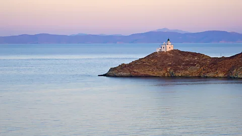
AlamyFor generations, this teardrop-shaped isle has been known as a cool summer escape for Greek families from the mainland.
This summer, as Greece endured deadly heatwaves, tourists and locals alike have been looking for relief. Yet, one Cycladic island has long been known as something of a breezy oasis where mainlanders have long fled to escape the scorching Greek heat: the teardrop-shape isle of Kea, or “Tzia” as it’s called by locals.
As the nearest Cycladic island to the mainland and a one-hour ferry ride from Athens, Kea was known as Hydroussa (roughly: “water island”) in ancient Greek mythology thanks to its abundant springs that feed its lush vegetation. Today, the 2,500-person island is home to a collection of sleepy villages and hamlets, interspersed with the second homes of affluent Athenians who come to splash in Kea’s crystal-clear water and marvel at its renowned sunsets.
“Kea used to be, and still is, a weekend haven for Athenians, who would leave their offices on Friday afternoon and arrive effortlessly on the island,” explained local guide Sotiria Antonopoulou. “The routine was simple yet fulfilling: a refreshing swim at Gialiskari beach followed by a leisurely dinner at Aristos in Vourkari. On Sunday afternoon, they would take the ferry back to Athens. This ritual, cherished for its simplicity, will be repeated next weekend. It’s a place that calls you back.
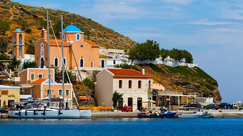
Stepping off the ferry at the island’s main port, Korissia (also known as Livadi), visitors may soon notice that Kea feels quite different than Athens – and there’s a reason why.

 Alamy
Alamy“During summer, the Aegean islands – and especially the Cycladic islands – experience lower maximum temperature than the mainland,” explained Dr Kostas Lagouvardos, research director at the National Observatory of Athens. “The strong northern seasonal winds, called Etesians or meltemia, help to maintain air temperature in the islands at cooler conditions than in mainland Greece. For example, during the long-lasting heatwave of July 2024, when temperature exceeded 40C in many Greek areas, temperature in the islands remained well below 35C.”
Kea’s rugged, mountainous interior funnels these winds through its narrow valleys, creating something of a natural ventilation system. The island is also home to the Cyclades’ largest oak forest that creates a shady oasis within these cooler islands.
But it isn’t just the island’s geography and topography that set it apart. Kea’s history dates to the Cycladic era (3200BC and 1050BC) and this small, 130 sq km island was once carved into four city-states – the most notable being Karthea, which thrived from the Archaic period (8th Century BC) until the early Byzantine period (6th Century AD). To understand the island’s roots, lace up your hiking boots, head to the hamlet of Stavroudháki and follow a paved path up into the mountains, where you can gaze down on the island’s dense oak forest and continue towards the remnants of two temples: the Doric temple of Athena and the Temple of Pythion Apollo, which both date to the 6th Century BC.
Along the north-eastern part of the island (near the village of Agia Irini) archaeologists have unearthed houses and workshops dating to the late Neolithic Age (around 3300BC), offering a glimpse of early Cycladic life. The most notable finds are the unique “spouted pots” and “Cycladic figurines” – small clay sculptures with distinctive features, particularly the “bell-shaped” skirts – which can now be found at the Archaeological Museum of Kea. Located in Ioulida, the island’s ancient (and current) capital, the museum houses a comprehensive collection of ancient artefacts from the island’s past, spanning from the Neolithic period to the Roman era.
 Alamy
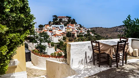
AlamyOne such hike is into the mountainous capital village of Ioulida, where you’ll find the remains of a Venetian castle and the stone-carved Lion of Ioulida, which dates to 600BC and is rumoured to have been built by the same architect who designed Athens’ famous Acropolis. In Ioulida, whitewashed walls and a mixed palette of orange, reds and blues colour the village amongst the tiny sinuous pathways, all of which are pedestrianised. In the centre of the square, hikers can recharge in a cluster of tavernas, an ice cream shop and a small grocer that has been in the same family for more than 40 years.
Ioulida is surrounded by a series of traditional agricultural terraces supported by hand-built stone walls, which keep the sloping land structurally stable while also allowing the soil to remain in optimal condition for cultivation throughout the seasons. These terraces wrap around the island’s many valleys and hills and are home to olive orchards, herb gardens and arable land used by grazing goats and mules. When damaged, they are repaired again, continuing this tradition for the future.
While not entirely isolated, Kea leverages its natural resources and traditional agricultural practices to achieve a remarkable degree of self-sufficiency. Visitors can taste this in the island’s renowned honey, pollinated exclusively from the nectar of thyme flowers. This plant, alongside a diverse collection of herbs including chamomile, sage, lavender, oregano, rosemary, verbena, basil and the distinctive thrymbi, abound on Kea, emitting a natural perfume for hikers as they explore the hinterlands.
 Alamy
AlamyLocated in Kea’s central and eastern interior, the island’s ancient oak forest doesn’t just keep it cool, but has traditionally been a driving force behind Kea’s economy. The caps of the acorns have long been prized for their tannins, and for centuries, islanders have used them in the production of vegetable leather tanning (a more durable and eco-friendly alternative than tanning using animal skins). These forests also help to prevent soil erosion and contribute to rainwater retention.
Head down the winding and inevitably narrow roads to the coast and you’ll reach Kea’s famously clear water. The island is renowned for its secluded beaches – namely Gialiskari, Kambi and Koundouros, which remain the most popular spots for locals and day-tripping visitors.
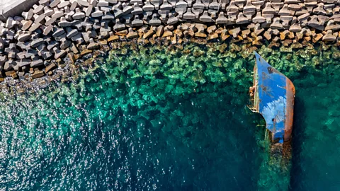
Interestingly, one of Kea’s main draws isn’t actually on Kea, but below the ocean, as a wealth of shipwrecks are scattered across the nearby seabed. The Kea Underwater Historic Site marine park is home to three historic shipwrecks that have been fully accessible to divers since 2022. The most famous is the HMHS Britannic (the sister ship of the RMS Titanic), which sank off Kea’s coast in 1916 after striking a German naval mine. Add in an offshore reef, numerous underwater caves and a variety of scuba outfitters and Kea is emerging as one of the best diving scuba diving destinations in the Mediterranean.
And when you finally do come up for air in Kea, chances are it’ll be to a pleasant, cool breeze.

Fromis_9 to release farewell single before leaving Pledis Entertainment

The Best of BoF 2024: Fashion’s Obsession Reaches Fever Pitch

Your daily horoscope: December 23, 2024

2025 World Junior Championship Group A preview | NHL.com

2025 World Junior Championship Group B preview | NHL.com

Japan figure skaters out to show strength in numbers at 2025 worlds

Holiday market opens just in time for last-minute shopping

A universal tagging system for pangolins, world’s most trafficked mammal

Local business gives back to the less fortunate
