Jobs
The SCW Q&A: Physics vs. AI; hype or reality; potential cyclones; tornado or not; our day jobs are safe
Houston may be settling into its summer weather doldrums, but let’s face it: In June, the skies over the region were a happenin’ place. As happens this time of the month, Eric and Matt have cracked open their inboxes and answered your queries.
Got a burning question of your own? Smash the Feedback button in the blog’s sidebar, respond here with a comment or talk to us on our socials: X, Facebook, Instagram, Threads, Mastodon, Bluesky and LinkedIn.
Q. So I’m curious which model actually panned out (regarding TS Alberto). Was it the regular models or the AI models? I remember it being mentioned that there were some differences between them a few days ago.
Thanks for the question. We took a look at this in the immediate aftermath of Alberto, and in terms of track the physics-based models significantly outperformed most of the AI-models. Essentially, some of the AI models wanted to bring the tropical system much further north into the Gulf of Mexico (toward Texas) whereas the traditional models kept it bottled up in the Southern Gulf, which is what ultimately happened.
I’ve also been looking at the AI guidance more frequently for non-storm events and so far I’m not convinced it’s any better (or even as good as) the physics-based models. Of course this is just my personal experience. The best way to determine the value of these new models will be using rigorous, comparative studies of what the models predicted across a range of variables against what ultimately happened. Now that the AI forecasts are coming out in real time, those kinds of studies can be done. I look forward to seeing the results in the coming months and we’ll be sure and share any interesting findings here.
–Eric
Q: Is the news media hurricane prediction for 2024 hype or more on the real side? I am debating getting a generator, but don’t want to buy into the hype if that’s what it is.
A: It’s certainly not hype. But you have to look at it logically. The data almost unanimously suggests that this should about as active a hurricane season as we could have. Thus, the seasonal forecasts are all quite bullish on hurricane development.
In fact, one thing we did at our companion site The Eyewall back in early June was to expand on ways that the active hurricane season forecasts could bust. The reality is that it could bust. Absolutely. Would that mean the preseason forecasts were all hype? As a scientist, I will tell you certainly not. As a member of the public, I get why you’d have that opinion though. So we encourage people to look at the decisions they make with regard to seasonal hurricane forecasts with nuance.
Were you probably going to get a generator anyway? We’ve had far more events non-tropics related that have caused extensive power outages in our area in recent years. Just consider the whole picture. And in this case consider a busted forecast a good thing if it happens.
–Matt
Q. Why is Potential Tropical Cyclone One not called “Tropical Depression One”? I thought a storm was called a tropical depression before it became a tropical storm?
It’s all a bit confusing, isn’t it? But the intent here by the National Hurricane Center is good. A “Potential Tropical Cyclone” is sometimes issued before a tropical system becomes a ‘depression’ or a ‘tropical storm.’ This happens when a system could bring tropical storm or hurricane conditions to land within 48 hours.
Essentially, forecasters from the hurricane center do this when they want to highlight the threat of a tropical system to land, but that system has not yet formed. Why do this? Because sometimes a tropical storm does not intensify until very shortly before landfall, at which point formal warnings are often too late to be actionable. The hurricane center started doing this in 2017, and you can find more information here.
–Eric
Q: Curious to know how the NWS determines if a tornado occurred and categorizes it after the event? Is it based on eyewitness accounts, damage, etc?
A: There are a few ways to confirm a tornado has occurred. Some larger tornadoes have “tornadic debris signatures” on radar, where you can see the radar showing you lofted debris from tornado damage. The most obvious and easiest way to suspect a tornado is eyewitness accounts.
But sometimes well-meaning people think something is a tornado when it is not. That’s why the NWS usually sends out a survey team to go investigate damage after a storm if a tornado is suspected. They can combine spotter or eyewitness accounts with radar data to determine exactly where to look for tornado damage. Generally speaking, if the damage is all pointed in one direction, that’s a tell-tale sign of straight line winds, or a microburst/downburst, not a tornado.
But if the damage is more chaotic or pointed down in different directions, that’s a probable sign of a tornado. This page from the NWS in Binghamton, NY shows sort of how they go about this process.
Rating the tornado’s intensity is another matter. There is some subjectivity involved, but in general, the damage indicators as provided in the Enhanced Fujita scale provide a decent categorization for a tornado.
–Matt
Q. You are all hype. I thought your website was dedicated to providing weather insight for Houston without the hype but your Stage 2 flooding article was all hype!! Don’t quit your day job!
A. Let me put your weary and worried mind at ease: we won’t be quitting our day jobs. My day job is writing about space exploration for Ars Technica. Matt is a meteorologist for an energy company in Houston. Would you believe that Space City Weather is hobby for both of us, a second job we do to try and help the community?
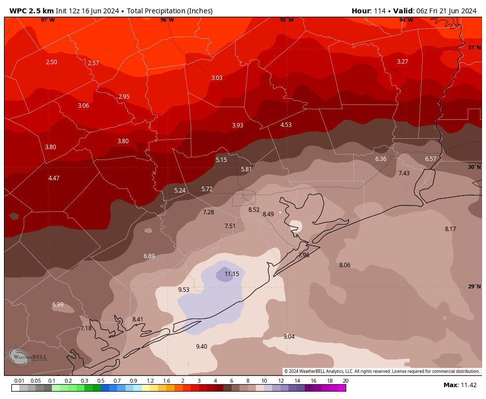
I do think it is useful to revisit our thinking about issuing a Stage 2 flood alert on Sunday, June 16. Here’s the post, which we published at 9:53 a.m. Note that this was Father’s Day, and Matt and I spent a couple of hours that morning strategizing, thinking, and writing about the forecast. I mention that just so you understand we’re pretty dedicated to this stuff.
That morning we actually gave some thought to issuing a Stage 3 warning for coastal areas, but I decided it was best to hold back for a time. At the time some of the modeling was rather dire (showing upwards of 20 inches of rain across parts of Houston in some instances). The ‘official’ precipitation forecast from NOAA showed a bullseye of 12 inches of rain just south of Houston, and the flood threat was very real for coastal areas. In any case, we felt it was time to raise the alarm about the potential for significant flooding in the Houston region for the coming week. So we pulled the trigger.
Some uncertainty definitely remained—we caveated our forecast with the following statement, “Our forecast modeling remains a bit split as to whether the heaviest rain will fall near Galveston, or further south closer to the Coastal Bend.” The latter is precisely what happened.
In forecasting, you win some, and you lose some. All we can really do is to try and do our best, and that’s just what we do here.
–Eric


Lateral Fitness Equipment Market to Witness Huge Growth |Precor Incorporated, Johnson Health Tech

TOPLINE FITNESS: Why everyone’s into line dancing

Riyadh Air Sets Sights On The Skies: Unveiling Ambitious Growth Plans – Travel And Tour World

Letters to Sports: Drafting Bronny won’t hurt Lakers as much as LeBron’s contract will

Princess Kate’s top 5 wardrobe upcycles

Rochester’s Roca Climbing and Fitness youth are ready to conquer USA Climbing Nationals

Main Character of the Week: Woman who refuses to put shopping carts away

Fully Remote Jobs at Google You Can Apply for in July 2024

Save on Viral Stanley Tumblers During Amazon’s Early Prime Day Fitness Deals
